The battle for your wrist is about to get a lot more interesting.
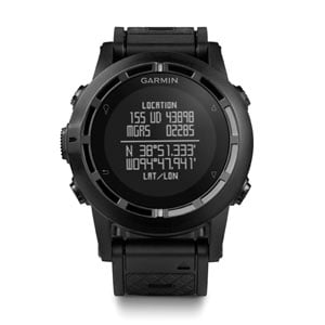
In March, Garmin will be shipping the much anticipated Fenix 2 GPS fitness and adventure watch. This latest entry into what is becoming quite a crowded market, takes all of the great features from the original Fenix and amps them up a notch, giving outdoor enthusiasts everything they could hope for in a training timepiece – and then some.
Like is predecessor, the Fenix 2 is ruggedized for the outdoors, including being waterproof down to 50 meters. As you would expect, it comes with an altimeter, barometer, a 3-axis compass and built in GPS tracking for navigation. That includes 10,000 track points and 1000 way points. It has sun and moon charts built in, a hunting and fishing calendar, dual timezones, and a host of of time keeping options. It also features ANT+ integration to connect with heart rate monitors and other devices as well.
But, the Fenix 2 brings some interesting new features to the table as well. For starters, it has onboard Bluetooth functionality that allows it to be paired with a smartphone for tracking data. A new Ski-Board mode is designed to specifically track movements both horizontally and vertically, while an improved battery will offer up to 50 hours of use in GPS mode, and five weeks while being used as a standard watch. Improved swim and bike modes make it a better option for triathletes as well, while still managing to bring more options to the table for runners too. If that wasn't enough, the Fenix 2 will even serve as a remote control for Garmin's VIRB action camera.
Perhaps most importantly of all, Garmin has made the watch's interface far more intuitive to use. The original Fenix could be a bit confusing at times, but this time the OS has been tweaked to make everything more accessible. This really helps when all you want to do is get moving, rather than standing around waiting to get your watch in the right mode.
When it ships next month, the Fenix 2 will carry a price tag of $399 for the standard model and $449 with a heart rate monitor. Those are the same price points that the original Fenix launched at as well. At the moment, it looks like a very promising new entry into the GPS watch category, and I'm looking forward to hearing more about how well it performs.
This news comes at the height of my frustration with my Suunto Ambit, one of the main competitors to the Fenix. Last week, after charging my Ambit I put it on and set off for a trail run. When I went to start my GPS tracking, the face was completely blank, although touching the buttons emitted a beep as it would when it was functioning normally. After returning from the run, I plugged it into my computer, where it was immediately recognized, but still there was nothing appearing on the screen.
I dropped Suunto a tech support know to inquire as to how I should proceed, and I was informed that I'd have to drain the battery, then let it charge for five hours straight to correct the problem. I'll have to take their word for it, because now that the battery if fully charged, I'll need to wait a month before it is drained again. In GPS mode, I could drain it very quickly but I can't access that without being able to see the screen. So, my $500 GPS watch is essentially useless for the next month until the battery drains on its own, and then I have to hope that recharging it will get the screen working again. To say that I am not pleased to be able to use my watch for the next several weeks is an understatement. Perhaps the Fenix 2 will be a viable option for a replacement.
Showing posts with label GPS. Show all posts
Thursday, February 20, 2014
Friday, December 13, 2013
Gear Closet: SPOT Satellite Messenger Gen3
When it was released a few years back the SPOT Satellite Messenger was a revelation to the outdoor community. Not only did it allow us to call for help in case of emergencies, it allowed us to send preset messages back home to let the know everything was okay, even while we were in remote areas. On top of that, it shared GPS coordinates online, giving friends and family the opportunity to see where we were located at any given time. All of that was rolled up in a small, lightweight package with solid battery life and an easy to use interface. The device was later updated with some evolutionary changes that slimmed down the Satellite Messenger slightly and added some measures that made it more difficult to inadvertently set off the SOS button.
This past summer, SPOT released the Gen3 Satellite Messenger which brings more substantial improvements to the Messenger. The device did get a bit larger in size but it made up for it much improved battery life. The new model is capable of running for twice as long as previous Satellite Messengers, which is an always a welcome upgrade. That improved battery life is put to good use, allowing the new device to be much more active. Two new GPS location sharing setting are available, allowing users to post updates every 2.5 or 5 minutes, in addition to the standard 10, 30 and 60 minutes. Sharing coordinates that often is probably overkill when backpacking in the backcountry, but it is nice to know the capability is there should you need it. In a further battery saving mode, the new SPOT unit will even shut itself off when it detects that you haven't moved for an extended period of time. That puts it into battery saving mode to conserve power. As soon as you're back on the go, it'll resume sharing data at the usual rate that you've set.
The new model also has multiple ways to keep itself charged as well. In addition to the standard, long life, rechargeable battery pack, the Gen3 is also capable of using off the shelf AAA batteries, which don't have the luxury of lasting as long as the rechargeable pack, but they are inexpensive, easy to find, and small enough to easily carry. The device can also be powered directly from a USB port, which can come in handy when wanting to use it to track a vehicle for instance and you don't want to run the batteries down completely.
Of course, the Gen3 still does everything the old models did in terms of sending pre-canned messages and having the ability to call for an emergency evac. Those features are often what owners most want out of the device, eschewing the tracking abilities in favor of at least being able to travel more safely and confidently in remote places.
I've had the good fortunate of testing the Gen3 for several months now and feel that it is a solid update to a device that was already quite good. It remains lightweight and durable, it tracks accurately and its ability to communicate with others back home, remains solid and reliable. Essentially, it is everything that we've come to know and love about previous SPOT devices, just improved in some important and useful ways.
The Gen3 also remains very affordable. It carries an MSRP of $169.95, which is a low cost of entry for a device that provides some excellent safety measures for our adventures. Of course, the Satellite Messengers itself isn't very good without service, and in order to use it you'll need to sign up for a monthly plan. Basic service runs $149.95 for the year, or about $12.50 per month, with extended tracking abilities adding more expense to the price tag.
With the holidays just around the corner, the SPOT Gen3 would make a great Christmas gift for your favorite outdoor enthusiast. It gives them the ability to travel in the remote corners of the globe without worry, and it'll give you peace of mind knowing that should an emergency arise, they'll be able to quickly and easily call for help. I can't think of a better gift for them or you.
The SPOT Gen3 is a solid update in every way, giving first time buyers the best device the company has ever created. The Gen3 is so good in fact, that it should entice owners of previous models to upgrade as well. The improved battery life is worth the update alone, but the other features are certainly icing on the cake.
Wednesday, November 20, 2013
Google Brings Street View To U.S. And Canadian National Parks
I've always been a big fan of Google's Street View technology. It's the amalgamation of the excellent Google Maps and photos that are taken and geo-tagged at various locations around the planet. The results are that we can explore a map from above then with a simple click, zoom down to street level to see exactly where it is we'll be traveling. It can be tremendously useful when visiting a place for the first time and it is often fun to explore an area right from your computer.
For some time now Google has been using the Street View tech to map some really cool locations. For instance, you can visit the Galapagos Islands, the Great Barrier Reef and even Everest Base Camp directly from your browser. But today, the Internet search giant has announced that by working with the U.S. National Park Service and Parks Canada, 44 national parks have been added to Street View as well, allowing us to take a virtual escape to those destinations even when we don't have time to actually go ourselves.
Some of the locations that been added include Sequoia National Park, Joshua Tree and Mt. Rushmore. You can also pay a visit to such historical landmarks as the Alamo, the Lincoln Memorial and the National Mall in Washington DC. If you're looking to head north of the border, check out Moraine Lake and Lake Louise in Canada's Banff National Park as well.
Of course, I'd never even begin to suggest that Street View is a viable option for going to visit these places for yourself. It is however, fun technology that allows you to scout ahead before you actually go in person. It is also a nice way to escape the office, even if for just a few minutes, during a particularly long and boring day. It is also a nice reminder of how far we have come in terms of mapping technology. I hope Google continues to expand on these initiatives in the years ahead.
Wednesday, October 23, 2013
Adventure Tech: Garmin Delivers Yet Another GPS Watch To Consumers
GPS technology company Garmin has released yet another GPS watch for consumers to ponder over. This time it seems less fitness/sports oriented and more aimed at a law enforcement/military crowd, although it brings a host of options that I'm sure many outdoor enthusiasts will find appealing. It also happens to deliver them in quite an attractive package.
The new watch is called the tactix and it retails for $450. It sports a high-sensitivey GPS sensor with automatically calibrating altimeter and a 3-axis compass. It's built in memory allows the device to store up to 1000 waypoints and 10,000 track points, and allows the wearer to quickly and easily retrace their steps back to previous positions. In a nod to its military roots, the U.S. version of the watch is preloaded with tidal data and all versions include Jumpmaster software for airborne personnel. It also features sun/moon data and a calendar for hunting and fishing. A stopwatch, countdown timer, world clock, and alarm functionality are all built in as well of course, and as with most GPS enabled watches, this one will tell you distance traveled, speed, calories burned, etc. The tactix will also pair with Garmin's heart rate monitor and bike pod to measure performance and will even control the company's VIRB and VIRB Elite action cameras.
The tactix is designed to be rugged and survive in the outdoors. Its case is tough and durable, making it water resistant down to 50 meters. It's all black styling is designed to be non-reflective and subtle in nature, while the built in battery can reportedly go 50 hours between charges with GPS enabled and 5 weeks when being used as a standard watch. That performance is actually quite good for a watch of this kind.
The new watch is available now.
Wednesday, October 16, 2013
Video: New Navigational System Ensures You're Never Lost Again
If you're looking for a good chuckle today, you'll definitely want to check out this video. It is in French but the English subtitles still hammer home the point. It introduces a new navigational system that has more features and functionality than any GPS on the market. It is so unbelievable that you'll probably want one for yourself. What is this new high-tech device called? A map!
Thursday, September 26, 2013
Adventure Tech: New Options For Hammerhead Bike Navigator
Remember the Hammerhead bike navigation system that I wrote about last week? It's the handlebar-mounted electronic device that when paired with your smartphone via Bluetooth will give visual clues on how to navigate through a route by using integrated LED lights. The system can also be used a rechargeable headlight and it uses route sharing to create a social element to your rides as well. It is certainly a unique and interesting product that has potential, particularly with commuter cyclists.
The Hammerhead Kickstarter campaign is now a couple of weeks from wrapping up and in an effort to jumpstart the fundraising options the designers of the device are now offering some new incentives to draw in potential customers. First, they're offering an "early bird" special for the first 500 people who contribute to the campaign that will allow them to purchase the Hammerhead for $68. Considering the navigator is expected to retail for $100 when it hits production that is a substantial savings for those who want to back the device now.
The other, perhaps more intriguing incentive, is a new limited edition version of the Hammerhead that will be available in translucent slate gray. Only 500 of this model will be available as well and they will come with their own unique serial numbers and will be engraved with the cyclists personal information such as name, address, emergency contact number and so on. The limited edition model is available from the Kickstarter page as well for a price of $78.
The designers of the Hammerhead are looking to raise $145,000 to get their device into production. Right now, with 16 days to go, they're sitting at about $48,000 in funding. If you're interested in this navigation system at all, this is a good opportunity for you to pre-order one before they are built and get it a substantial discount. The limited edition version with the engraving would make a great gift for your favorite cyclist by the way, giving them a cool, high tech navigation tool while showing you care about their safety at the same time.
In case you missed last week's post, here is a video of the Hammerhead in action. It helps explain what it does much better than I can.
Labels:
Cycling,
GPS,
Kickstarter,
Navigation,
Technology
Thursday, September 19, 2013
Adventure Tech: Hammerhead Bike Navigation System
GPS navigation seems to have proliferated through just about every portion of our lives. Having GPS built into our smartphones has been a game changer and many outdoor enthusiasts now have GPS watches to aid them in their active pursuits. One company is trying to bring a new navigation system to cyclists as well in the form of the Hammerhead, a revolutionary new device that uses a series of LED lights to direct riders on where to go.
The device attaches to the handlebars of your bike and pairs with an iPhone or Android device via Bluetooth to provide navigation information. A specially designed app then sends specific turn-by-turn data to the Hammerhead itself which uses its embedded lights to indicate where and when to turn, distance to the next turn, and how close you are to your destination. It is a simple but effective interface that allows riders to glean a lot of information without ever having to take their eyes off the road.
The Hammerhead app uses crowd sourcing to share information about bike routes and the best way to navigate through urban settings and trails alike. It allows users to upload and share their favorite rides with the online community, which makes the device's way finding smarter and more accurate. Data can also be shared with other apps such as Strava and MapMyRide as well.
As if all of that wasn't interesting enough, the Hammerhead also functions as a headlight and includes two side lights for added visibility. A red dot on the top serves as a compass too, providing even more functionality in a simple design.
Currently the team behind the Hammerhead is seeking funding via a Kick-starter like campaign. If you're interested in the product you can learn more about it and back the project by clicking here. The designers of the device are seeking $145,000 to get it off the ground and they are currently at about $42,000 with 23 days to go in their campaign. You can also find out more on the Hammerhead Facebook page.
Seems like an innovative looking piece of technology. I like that it is so simple and yet provides quite a bit of information without having to really look at it too closely. I think the Hammerhead has lots of potential but to really tap it they'll need a good, active community. Time will tell if that happens.
Monday, September 16, 2013
Adventure Tech: Garmin Introduces The Forerunner 220 and 620 GPS Watches
The competition in the GPS fitness watch market continues to heat up as Garmin introduces two new models to tempt runners. The company, which has a long history in both GPS devices and sports watches, has expanded its Forerunner line by creating the new Forerunner 220 and 620 models, both of which bring some nice new innovations to the product space.
The most notable addition to these new watches are the color screens which are vibrant, easy to read and make use of colors to provide information to runners. For instance, there are indicators on the screen that will turn green to let the user know that they are safe to workout while red indicators will tell them it may be time to take a rest day.
That's just the start of what these watches can do however. When paired with a heart rate monitor they can also estimate an athletes VO2 max to help train them more efficiently and track progress. That same estimate can be used to predict performance in a race as well and suggest options for recovery too. The watches can be paired with a smartphone via Bluetooth to help keep track of a variety or workout statistics, such as cadence, vertical oscillations and so on. It can even record the runner's position and relay live tracking to friends and family back home.
Both watches will begin shipping this fall with the 220 carrying a price tag of $249.99 for the watch only and $299.99 when bundled with a heart rate monitor. The 620, which features a touchscreen display that can be used through running gloves, will set you back $399.99 for the watch and $449.99 with the heart rate monitor. Those prices put them in the medium to high end of the market but competitive with similar products from competitors.
Tuesday, August 20, 2013
Adventure Tech: Garmin Introduces VIRB Action Camera
The already crowded action camera market, currently dominated by GoPro, just got a bit more crowded. Garmin, the company so well known for making GPS devices, has released two new enteries for aspiring filmmakers to consider in the form of the VIRB and VIRB Elite. Whether or not they'll be able to make a dent with consumers remains to be seen, but they are packing some serious technology under the hood.
The VIRB is capable of capturing video in resolutions up to 1080p HD, which is pretty much standards for any action camera these days. But Garmin's device also features onboard image stabilization and lens distortion correction, which help to make the footage just a bit cleaner and clearer. Battery life is a rated to be a solid three hours and both versions of the VIRB are capable of capturing still images while video is recording. A built-in 1.4-inch display allows the user to watch video already shot or see exactly what they are filming at all times. The VIRB Elite also comes equipped with onboard WiFi and GPS, while both units feature ANT+ connectivity for pairing with other devices.
Garmin knows their market well and built the VIRB to appeal to the outdoor crowd. The camera is rated for IPX-7 waterproofing, which means it can survive under a meter of water for up 30 minutes. That makes it tough enough for most waterborne adventures, although if you want to take it diving you'll need to purchase the optional dive case. A number of mounts will be available for the VIRB as well allowing the user to connect it to their handlebars, helmet, surfboards, kayaks and more. A built-in HDMI port and a microSD card slot rounds out the package. The camera can support up 64GB of microSD storage, which is enough for as much as 7 hours of 1080p footage.
The VIRB and VIRB Elite will be available in September with a price tag of $300 and $400 respectively.
Monday, July 29, 2013
Adventure Tech: SPOT Announces Third Generation Satellite Messenger
On the eve of the start of the summer Outdoor Retailer gear convention, SPOT has announced the release of its new third generation Satellite Messenger. The new device, which is available at retail now, features some significant upgrades over previous SPOT devices, allowing outdoor enthusiasts to travel through the backcountry more safely then ever before.
Perhaps the biggest upgrade with the SPOT Gen3 is in the area of battery life. The new model can operate twice as long between charges as compared to previous models, which were already fairly energy efficient. That extra battery life is put to good use in terms of tracking as well, allowing this new device to update its location more regularly. The SPOT Gen3 is capable of sharing its location every 5, 10, 30 or 60 minutes, allowing friends and family to trace your path while out on an outdoor adventure. There is even a new mode that will allow the unit to share precise locations every 2.5 minutes, which my friends who are race directors for adventure races will surely appreciate. There is even a new mode that automatically sends tracking information when the SPOT Gen3 is moving but quits transmitting when it has stopped. This motion sensor will help save battery life while still providing regular updates on the users progress.
Speaking of battery life, the new SPOT device has improved in that department while also adding more ways to keep it powered. It can be operated using standard AAA batteries of course but the device now has the option for using rechargeable power cells or run off a direct connection from a USB power source as well. This lends a nice level of versatility to the Gen3 Messenger and means that there are more ways for us to keep it functioning while out in the field.
As with previous versions of the device, the new model allows users to send an S.O.S. message when they get into trouble or send pre-canned message to let friends and family know that they are okay. This simple, yet effective, messaging system is at the heart of what SPOT was intended for and the company claims that since it's launch a few years back, SPOT Messengers have been responsible for more than 2300 rescues worldwide.
The Gen3 model looks a bit larger than the older versions of the Messenger. It has also received a redesign that includes larger buttons and integrated loops designed to make it easer to use and carry. The unit remains waterproof and ruggedized of course, allowing it to take plenty of abuse while in the field.
I have an appointment to meet with the folks at SPOT while I'm at OR in a few days. I'll post some impressions on their new products, including the new SPOT Global Phone when I get the chance.
Wednesday, July 24, 2013
Adventure Tech: Magellan Introduces Smart Running Watch
Over the past couple of years there have been some significant advances in terms of sophisticated watches for use while running, cycling or doing just about any other outdoor exercise. Suunto and Garmin in particular have gone head-to-head in an effort to expand this market. Consciously absent from that competition was Magellan, a company that is known for building excellent GPS navigation devices but hadn't jumped into watches just yet. That all changed yesterday with the announcement of their latest product the Echo. A watch that pairs with your smartphone and gives you full control of fitness apps directly from your wrist.
The Echo uses Bluetooth technology to connect the watch with your iPhone or Android device to unlock all kinds of potential. The link lets your smartphone handle most of the heavy lifting and while streaming data about your pace, heart rate, distance and so on directly to the screen of the watch. You can also control the apps from the Echo, including full control over your music as well. If your favorite fitness app provides notifications they will appear on the watch as well, keeping you full informed at all times about the state of your workout. Your performance can then been analyzed and shared over social media too, if you're into bragging about your killer times to your friends.
Echo uses an open API designed by Wahoo Fitness for use with apps. That means that it should be easy for many of the top running or cycling apps to integrate support for the watch, but before they can be used with one another, those apps will need to be updated. Magellan says it is working closely with some of the top apps for iPhone and Android to get them ready for the launch of the Echo, which is expected to come in the 4th quarter of this year. The new watch will be officially unveiled next week at Outdoor Retailer and I hope to get a better look at it when I'm there.
Magellan is taking an interesting approach with the Echo. While the other companies creating similar products have tried to cram as much technology into the watch as possible, Magellan has instead decided to pair the watch with a smartphone and let that device do all of the heavy lifting. Since mobile phones already have integrated GPS and a host of other technology, there is no need for it to be on the watch itself. That should make this a much more lightweight and energy efficient product. In fact, while Suunto and Garmin's watches feature built-in rechargeable batteries, the Echo uses an easily replaceable watch battery that you can buy in any drug store. Using Bluetooth 4.0 technology, this watch should sip power slowly and last quite a long time on a single battery.
We'll have to wait to see how well Echo performs. If it receives good app support, it should be quite an interesting product. I don't personally run with my smartphone, but this might give me an incentive to change that. Looking forward to learning more at OR.
Monday, June 24, 2013
Adventure Tech: Android Powered GPS By Garmin
Garmin, one of the leaders in consumer GPS technology, has taken the wraps off a new handheld device today that looks to be a promising new entry for outdoor enthusiasts. At least those with some extra cash to spend.
The new Monterra is expected to begin shipping in the third quarter (read: July or August) and will be powered by the Android operating system that is so common on many mobile phones these days. In fact, Garmin's new device resembles a mobile phone in many ways, simply lacking the ability to actually make calls.
The device comes equipped with built-in WiFi, enabling the user to download updates and add apps to the Monterra without ever connecting it to a a computer. It also features an 8-megpixel camera, 6GB of internal memory (expandable through the use of microSD cards) and a 4-inch touch screen that has been optimized to be used in the outdoors without the need for battery-crushing backlighting. As you would expect, the handheld is ruggedized and waterproof (IPX7) and can run off of either the included rechargeable battery pack or AA batteries. It includes Bluetooth 3.0, NFC technology, an FM radio complete with NOAA weather, a UV sensor for keeping track of the intensity of the sun and a barometer/altimeter that measure not only your changes in altitude but possible changes to the weather as well. Preinstalled apps will enhance functionality further and the Google Play Store will obviously be available to get Angry Birds on this bad-boy as well.
There is no word on exactly which version of Android the Monterra is running but I suspect it'll be the most recent release of Android 4.2 (Jelly Bean) that is available when it begins shipping. Battery life remains a questions as well, but that is always the case with a GPS device these days. Prices start at $650 for the base unit with a built-in world map while $700 will get you a version preloaded with U.S. Topo maps as well.
This looks like it'll be a great device and I'm sure it'll be a hit with the geocaching crowd considering how easy it should be to add cache's to the device. The price seems a bit steep but it seems like it packs in a lot of functionality. If it can provide good battery life, this may just be the new GPS handheld to beat.
Friday, May 3, 2013
Adventure Tech: Suunto Ambit2 GPS Watch
There is no question that one of the more well received GPS watches to hit the market the past couple of years has been the Ambit from Suunto. The watch was marketed as being designed for explorers and it showed in its functionality. With good GPS integration, the watch was perfect for heading out on the trails, as it provided directions, trackbacks, data on speed, altitude and so on. Now, the company has unveiled its second generation Abmit project, this time bringing more features for the outdoor athlete.
Available in two versions, the Ambit2 and Ambit2 S, the new version of the watch keeps its core functionality while adding some nice new options to the mix. For instance, the 2 S, which is the sport model aimed at endurance athletes, is a bit lighter and thinner than the original Ambit. It features ANT+ technology that allows it to connect to heart rate monitors, cycling power meter. That means it can provide all of the data to track your training efforts and improve performance. It does give up the thermometer, barometric sensor and altimeter that were part of the original Ambit package. The Ambit2 on the other hands, retains all of the abilities from the original model and mixes in the new multi-sport features from the 2 S. Both versions have the ability to run the simple Ambit apps as well.
The Ambit2 and Ambit2 S will be available to purchase this month. Prices haven't gone down any since the original Ambit was released. The Ambit2 will set you back $500-$650 depending on which unit you buy, while the 2 S will run $400 on its own and $450 with a heart monitor.
Labels:
Backpacking,
Cycling,
Gear,
GPS,
Hiking,
Mountaineering,
Running,
Technology
Wednesday, May 1, 2013
Video: DeLorme's inReach SE Satellite Communicator In Use
DeLorme's new inReach SE satellite communicator is quite the device, allowing us to send text messages, tweets and other updates from just about anywhere on the planet. It also allows loved ones to track our movement and gives us the ability to call for help should the need arise. That's quite a bit of functionality packed into one small gadget.
The video below is a beautifully shot commercial for the device that gives us a sense of how it can be used in the field. It features people doing some of our favorite activities, including mountain biking, rock climbing, backpacking and so on. The video does a compelling job of showing us why having one of these devices on us when we head out into the backcountry is a good idea.
Wednesday, April 17, 2013
Adventure Tech: TomTom Announces Line Of GPS Fitness Watches
TomTom, a company that is well known for its GPS devices, has announced that it is throwing its hat into the GPS fitness watch arena. The watches will come in two different models including one specifically designed for runners and the other for multi-sport athletes.
Both versions of the watch will feature large screens that are designed to be easy to read even while on the go. An innovative single-button control will make it easy to navigate through menus and options too. Each of these watches has the ability to track runs both indoors and outdoors and can sync and share that data through a variety of popular fitness websites. TomTom promises an ultra-slim design that will be comfortable to wear on just about any wrist and Bluetooth technology will link the watches to optional accessories such as heart rate monitors or a cadence speed sensor on a bike. The multisport model will also feature a built-in swim sensor for tracking laps and will come with a dedicated handlebar mount for cycling.
According to the press release from TomTom, these new watches will also include QuickGPSFix technology which allows them to connect to satellites faster so you can get started on your workout sooner. The company also says that data stored on the watch can be imported into social fitness sites such as MapMyFitness, RunKeeper, TrainingPeaks, MyFitnessPal and their very own TomTom MySports website. Battery life is reportedly about 10 hours, which is a little low when compared to some of the competition, but we'll see how well it actually performs after its released.
The two watches will be released this summer and while there are no prices announced yet, TomTom says that they will be competitive with similar watches from other companies.
To find out more, and sign up to get more information as it becomes available, click here.
Friday, April 12, 2013
Adventure Tech: DeLorme InReach SE
Last fall I reviewed the DeLorme InReach satellite communicator, finding it an excellent way to stay in touch while in remote areas of the world. The device uses the Iridium satellite network to communicate from remote corners of the globe, and on its own it's capable of sending brief pre-canned text messages and Twitter updates. But when paired with a smartphone via Bluetooth, the user is capable of sending what ever messages he or she wants. The two devices work well with one another and make for a solid communication system while on an expedition somewhere. But carrying two devices means you extra weight, plus the challenges of keeping everything charged. DeLorme has addressed this in their newest product, the InReach SE, which now comes with a built in touch screen that eliminates the need for a second device.
The InReach SE was just announced yesterday and brings some nice upgrades to the table. For instance, it now incorporates a bright, easy to read color screen that includes a virtual keyboard for sending any type of message you'd like. The device features all of the functionality you've come to expect from the satellite communicator, including global coverage, the ability to call for an SOS, and satellite tracking functionality. It also allows the user to post to popular social media network such as Facebook and Twitter. The device features a rechargeable lithium battery that is rated for 100 hours of use under typical circumstances and the entire unit is waterproof, dustproof and impact resistant.
Just because DeLorme added a screen to this model doesn't mean that you can't still pair it with a smartphone however. Bluetooth functionality is still built-in, which means you can pair a smartphone or tablet and gain access to the Earthmate Apps, which provide downloadable topographic and NOAA maps to help navigate in the backcountry. When paired with such a device, the InReach SE acts as the GPS receiver, while the smartphone or tablet is the screen that provides highly detailed navigational tools.
The new InReach SE comes with an MSRP of $299.95 and is available now. Seems like a great evolution of this product line and an improvement over an already great product.
Friday, February 22, 2013
Video: Garmin fēnix For The Trekker
Okay, I promise this is the last video I'll post about the fēnix GPS watch but I didn't want the hikers and backpackers to feel left out on the fun. This latest video from Garmin features German trekker Ferdinand Thies who thru-hiked the 2200-mile (3500 km) Appalachian Trail and used his fēnix to share his adventures with friends and family along the way. Ferdinand likes the watch because it is lightweight and helps him navigate through areas he hasn't been to before without the bulk of a traditional GPS device.
The most intriguing thing to me about the fēnix is that I pretty much do everything that Garmin has showed us in the video. Climbing, hiking, trail running and so on. That makes this one very versatile watch as far as I'm concerned. I haven't decided if I'll pick up the fēnix or Suunto's Ambit, but both are definitely on my "wish list" at the moment.
Thursday, February 21, 2013
Video: A Mountain Guide's Take On The Garmin fēnix
Judging from the amount of traffic that this series of videos from Garmin has gotten over the past few weeks, I think it safe to say that you are enjoying learning more about the fēnix GPS watch and how it can be used in our outdoor pursuits. The latest video features German mountain guide Christof Schellhammer, who worked closely with Garmin int he development of the fēnix. Christof shares how he uses the device to navigate through the mountains and the role it plays in helping him be a safer guide.
The more I see of these videos, the more I think I need one of these watches, which is kind of the point huh?
Monday, February 18, 2013
Video: Garmin fēnix For Trail Running
While we're on the topic of trail running today, here's another video in the new series from Garmin that extolls the virtues of their fēnix GPS watch. This time out we hear from French trail runner Sebastien Camus who competes in utramarathons and other endurance runs. He loves this watch because of how well it helps him train and since he once ran across New Caledonia for three days, non-stop and without sleep, he appreciates the long battery life too.
Thursday, February 14, 2013
Adventure Tech: RFLKT iPhone Powered Cycling Computer
Cyclists looking for a new gadget to help track their rides are going to love the RFLKT from Wahoo Fitness. Like other cycling computers, the RFLKT connects to your handlebars and displays information about your ride, including speed, distance and time. But unlike most other devices of this type, the RFLKT connects to an iPhone via BlueTooth, which allows it to do so much more.
In a sense, the RFLKT actually serves as a second screen for the iPhone, providing data from multiple cycling apps, controlling music, providing GPS functionality and even connecting to the Internet. It will also offer turn-by-turn directions, lap timers and the ability to connect with heart rate monitors, displaying that information on the fully customizable screen. In short, it is everything you could ask for in a cycling computer with some nice additional features as well. And since the two devices are wirelessly connected with one another, you can safely keep your phone in a jersey pocket at all times.
I'm not a big fan of listening to music while riding, but having the ability to control your tunes without taking the phone out is a nice option. If the RFLKT also had integrated caller ID and the ability to see text messages, this would be an almost perfect option. It definitely is intriguing however and since its based on an open platform, I'm sure we'll see some interesting things being developed for it. At $129, it is also quite affordable. There are plenty of cycling computers that cost more than that without nearly as much functionality.
Subscribe to:
Posts (Atom)